New research outlines the best locations for dams to avoid flash floods and to save lives.
The collapse of two dams in Libya last month caused widespread destruction, destroying livelihoods and causing thousands of deaths.
The horrifying disaster happened in the aftermath of Storm Daniel, which caused the dams to burst and forced Libya into a state of extreme emergency.
In a new study published in the Journal of Hydrology: Regional Studies, Dr Ashraf Ahmed, a flood expert and chartered engineer from Brunel University London, and researchers from Benha University and Zagazig University in Egypt have uncovered key details that dam designers and decision-makers should consider when constructing dams and selecting dam sites.
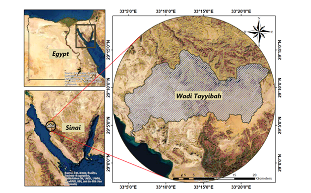
For the study, Dr Ahmed focused on an area in South Sinai, Egypt, called Wadi Tayyiba. It is a popular hiking area and has a history of flooding the city of Abou Zenima. This is caused by surface runoff water from the area when there is more water than the land can absorb.
“The floods in Egypt have resulted in numerous losses in terms of life, property and infrastructure, and most of the flood water is wasted despite the critical need for it,” said Dr Ahmed.
“It is important to take advantage of torrential rainfall, and dams should be developed with sub-basins - an area of land that drains rainfall to a storage place such as a reservoir or lake.”
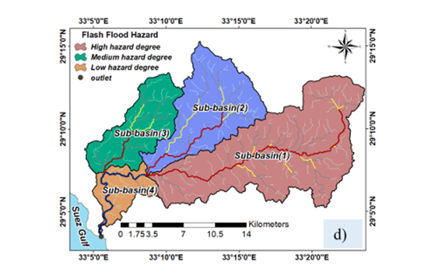
As well as using rainfall data and assessing the types of soil in Wadi Tayyiba, Dr Ahmed also used computer programmes to simulate the rainfall-runoff relationship in Wadi Tayyibah over a 100-year period. His analysis enabled him to create a flood hazard map for the area and identify cost-effective locations for dams.
The chartered engineer stresses the need for dam designers to consider the types of rocks found within a basin and whether there are any slopes. “Increased slopes cause more severe outflows of water and increase the risk of flooding,” he said.
In addition to this consideration, Dr Ahmed outlines the importance of assessing any highways that pass through an area to estimate the extent to which these roads will be impacted by surface runoff.
The study proposed a total of eight dams in Wadi Tayyibah and divided the area into four sub-basins alongside a storage lake.
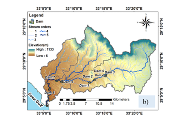
There are highways that pass through Wadi Tayyibah, including Sharm El Sheikh Road, and the area has nearly level slopes.
“The results of the study showed that a dam’s location should be chosen so that its length is appropriate and restricted between two high points,” said Dr Ahmed.
“It is important that there is a nearby lake or reservoir with a suitable storage capacity for the quantity of rainfall, making dams financially feasible and minimising the risk of flooding.”
The Brunel academic believes that his research is useful for decision-makers in selecting the best investment locations for storage dams around the world.
“As well as preventing flash floods and loss of life, the research also highlights the cost-benefit of dams being built in the correct location and their ability to support water storage for future purposes,” he said.
“In the future, we will seek to rely on artificial intelligence techniques and integrate them to forecast dam locations for rainfall harvesting and flash flood mitigation.”
‘Identifying cost-effective locations of storage dams for rainfall harvesting and flash flood mitigation in arid and semi-arid regions’, by Amir S. Ibrahim, Ashraf Ahmed, Islam S. Al Zayed, Ismail Abd-Elaty, is published in the Journal of Hydrology: Regional Studies.
Note: (c) Diagrams belong to the authors.
Reported by:
Nadine Palmer,
Media Relations
+44 (0)1895 267090
nadine.palmer@brunel.ac.uk